Powerful earthquake strikes Pakistan, raises new island
By Deborah Byrd in
on Sep 24, 2013
on Sep 24, 2013

Earthquake in Pakistan, September 24, 2013 via USGS
|
|
Most famous new island of 20th century is Surtsey. Read more.

A
new island, created in what one scientist called a “mud volcano,” has
risen from the sea off the coast of Pakistan, following the September
24, 2013 earthquake there. Image via DieWelt.
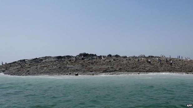
Not surprisingly, people are already out walking on the new island, as this BBC World News Facebook image shows. The BBC reports that there is already rubbish on the island from people who have begun visiting it.
Pakistan earthquake September 24, 2013 via USGS
The shifting sand layers are compacted and pressurize the water, which gushed upwards, carrying mud and sand along with it.
This ‘liquefaction’ of sand and mud layers take place after any earthquake, but these sudden islands are usually spotted after strong earthquakes, at least 7- or 8-magnitude events.
View larger.
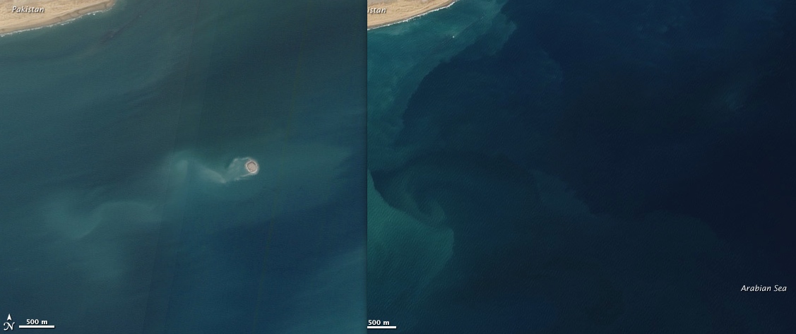
| New islands do rise from the sea floor on occasion. Image on left
shows an island that appeared on November 26, 2010, also formed by a mud
volcano, off Balochistan, Pakistan. Image on right shows the same spot
about a year earlier. Images via NASA Earth Observatory
Details of the quake from the USGS are below:
Event Time:
- 2013-09-24 11:29:48 UTC
- 2013-09-24 16:29:48 UTC+05:00 at epicenter
Depth=15.0km (9.3mi)
Nearby Cities:
- 69km (43mi) NNE of Awaran, Pakistan
- 115km (71mi) NW of Bela, Pakistan
- 171km (106mi) NW of Uthal, Pakistan
- 174km (108mi) S of Kharan, Pakistan
- 795km (494mi) ENE of Muscat, Oman

Pakistan earthquake zone map, via Wikimedia Commons. The September 24, 2013 earthquake took place 116 km (72 m) northwest of Bela on this map, which is in the blue zone (minor to moderate damage). USGS issued a red alert for estimated fatalities and orange alert for estimated economic losses for this quake. Nearly a day after the quake occurred, 238 deaths had been reported.
Large earthquakes are relatively common in Pakistan in contrast to other part of the world. Check out this list of Pakistan earthquakes from Wikipedia, and note that today’s earthquake is at least the third one since 2005 that measures 7.2 or greater on the Richter Scale. No fewer than four major tectonic plates (Arabia, Eurasia, India, and Africa) and one smaller tectonic block (Anatolia) are responsible for seismicity and tectonics in the Middle East and surrounding region, according to the USGS.
Bottom line: A large and powerful earthquake struck on September 24, 2013 in a remote, mountainous region of Pakistan. The quake measured 7.7 on the Richter Scale; that is a very large earthquake. It struck in Pakistan’s Balochistan region, its largest but least populated province. Reports are now suggesting that at least 238 people were killed in the quake. A new island formed from a “mud volcano” on the sea floor following the quake, according to scientists at the Lamont Doherty Earth Observatory at Columbia University.
---------------------------------------------------
Deborah Byrd

Deborah Byrd is Founder and President of EarthSky, which she
created in 1991. EarthSky is a digital publisher that brings science
and nature to millions of people around the world. Byrd also produced
the EarthSky radio series from 1991 to 2013. She has won a galaxy of
awards from the broadcasting and science communities, including having
an asteroid named 3505 Byrd in her honor. Besides blogging, Byrd is
Editor-in-Chief of EarthSky.org: Science News, Great Photos, Sky Alerts.
She is executive producer of a video series in Spanish - interviews
with scientists - that airs on Univision. A science communicator and
educator for 37 years, Byrd believes in science as a force for good in
the world and as a vital tool for the 21st century. Astrophysics, the
night sky and imagining space travel remain among her most enduring
lifelong passions.
No hay comentarios:
Publicar un comentario